Length: 5 Miles
Difficulty: Moderate
Information
City Map
Sunken Road Map
Battle Map

After Gen. McClellan was relieved of command because he allowed the Army of Northern Virginia to slip away after Antietam, President Abraham Lincoln appointed Maj. Gen. Ambrose Burnside to command the Army of the Potomac. Burnside wasted little time in devising a plan to move quickly and deceptively around Lee’s army to Fredericksburg so he could get a clear path to Richmond. The first part of the plan worked perfectly until the Union army got bogged down trying to cross the Rappahannock River. Due to administrative ineptitude, pontoon bridges that were to be delivered from Washington so the Union Army could cross the river arrived a week late. This delay and Burnside’s lack of imagination allowed for the Army of Northern Virginia to assemble along the high ground in Fredericksburg, forcing the Union Army to make the first move.
Marye’s Heights Assault Hike: I like to start this hike across the Rappahannock River at the Chatham Estate on Stafford Heights. William Fitzhugh built this home in the late 1700’s and was visited by many important Virginians, including George Washington, Thomas Jefferson, and James Monroe. Union Maj. Gen Edwin V. Sumner, commander of the Right Grand Division, used the home as his headquarters during the battle. The home, along with many other homes and public buildings in Fredericksburg, was also used as a Union hospital.

Park your car and walk towards the back of Chatham for a great view of Fredericksburg. During the time of the battle, Fredericksburg was home to only 5,000 residences. Here you can see two cannons pointed towards the town. Union artillery ran along the entire ridge, proving support to the Union infantry as they began to make their assault. The three church steeples you can see were here at the time of the battle and gave the Union artillerist great targets towards the town.

Walk over to the replica pontoon bridge and look down to the bank of the Rappahannock. It was below you to the right where Union engineers began constructing two bridges on December 11, 1862. It did not take long before Confederate Brig. Gen. William Barksdale’s Mississippians on the opposite bank began to take notice and open fire, driving the engineers to cover. The cannons along Stafford Heights began an eight-hour bombardment that launched over 9,000 shells into the town. The shower of lead devastated the town but failed to dislodge Barksdale’s men. The pontoon bridges were eventually completed after Union troops were ferried over and cleared the buildings of Confederates.
If you have time, enter the house to get a better understanding of the events that took place here and ask the park ranger to see the graffiti written by Union soldiers. After walking the grounds, follow the gravel road that leads from the parking lot until you come to River Road. Turn left and follow River Road until you reach Kings Highway. Turn right onto Kings Highway and follow it over the Rappahannock and into Fredericksburg. Turn right on Sofia Street and follow it until you find the Upper Pontoon Crossing Site between Hawke and Fauquier Street.
Here on the large rock is the 7th Michigan Infantry Monument. The 7th Michigan and the 19th Massachusetts volunteered to be ferried across the Rappahannock and clear Barksdale’s Mississippi Brigade from cellars and buildings along this bank. The pontoon bridges were soon completed, allowing the 20th Massachusetts to come across and take command of the streets. This allowed Union troops to spill into the streets and begin the widespread looting and vandalism that is a black mark on the history of the Army of the Potomac. If you look across the river and towards the right from the monument, you can see the Chatham Estate.

Retrace your steps back to the intersection and turn right on Fauquier Street. Follow Fauquier Street until you reach the next intersection. Across the intersection is the Rising Sun Tavern which was built by George Washington’s youngest brother around 1760 and was likely a Union hospital during the battle, due to it’s proximity to the pontoon bridges.
Continue on Fauquier Street for one more block until you reach Princess Anne Street and turn left. Continue of Princess Anne Street until you come to the Fredericksburg Baptist Church on the left. During the battle, this church, along with the other churches in the area, were used as a Union hospital. Continue on Princess Anne Street until you reach the Old Market Square. It is in this area where Confederate Brig. Gen. William Barksdale reassembled his men before giving up the city to the Union soldiers.
The Second Town Hall/Market House was built in 1816 and now is the home to a wing of the Fredericksburg Museum. It now stands where the original was built back in 1763. The building was used as the town hall until 1982. Continue on Princess Anne Street until you reach George Street. Across the street is the Farmer’s Bank building. In the spring of 1862, 30,000 union troops, commanded by General Irvin McDowell, occupied Fredericksburg. During the occupation, President Abraham Lincoln visited General Marsena Patrick on May 23rd at the Farmer’s Bank building.
On the other corner across the street is the Fredericksburg Presbyterian Church. If you look at the brick border along the corner of the intersection, you will see a plague that states that this corner is where Confederate Lieut. Gen. Thomas “Stonewall” Jackson planned the Battle of Fredericksburg on November 27th, 1862. The Fredericksburg Presbyterian Church also was used as a Union hospital after the battle and is where Clara Barton tended to wounded patients. The Courthouse copula next to you was used as a Union Signal Station during the battle.

Continue one block on Princess Anne Street to Hanover Street and turn right. This is the main route that many of the Union soldiers took on their way to assault the Sunken Road. Stay on Hanover Street until you reach the first hill, which is known as Federal Hill. This hill was used by Union artillery during the attack on Marye’s Heights and the house was used as a Union hospital. It has been stated that the shell that killed Confederate Brig. Gen. Thomas R. R. Cobb at the Sunken Road was fired from this hill.

The home on Federal Hill was built in 1792 and was the home where Brig. Gen. T. R. R. Cobb’s mother grew up. Before the battle, Cobb was fearful that Union soldiers would destroy his mother’s childhood home so he asked Gen. Robert E. Lee "to raise the black flag and give no quarter to any scoundrel that crosses the river." If you look up at the chimney, you can see bullet holes and scars from the battle.
Continue on Hanover Street until you reach Kenmore Street. It is hard to image now, but after Federal Hill, the town ended at the time of the battle and there were only fields, meadows and gardens leading up to Marye’s Heights. Under Kenmore Street is where the canal was located that was a daunting obstacle for Union troops on their way to Marye’s Heights. In the 1850’s, networks of canals were constructed to supply business and mills in and around Fredericksburg with water. As the Confederates made their way across the canal, they pulled up the planking that was in place to allow easy travel across the ditch. This caused the Union troops to bottleneck on three partially destroyed bridges or wade through the freezing water on their way to the Sunken Road.
Once across the canal, the Union troops had to redress their lines and begin their charge up the slope towards the Sunken Road and the Confederate Artillery that lined Marye’s Heights. Remain on Hanover Street until you reach Littlepage Street. The brick building on your right (801 Hanover Street) was here at the time of the battle and was surrounded by small buildings that no longer exist. As the Union attacks began to get repelled, the area around this house became a sanctuary for Union soldiers looking for a spot to escape the deadly fire from the Confederates.
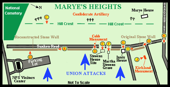
Continue on Hanover Street until you reach the Sunken Road and turn left. Up to a few years ago, you could still drive along this section of the park. Look closely at the two stonewalls that line the Sunken Road on your left and right. These stonewalls are the only sections that were standing at the time of the battle that still exists today. It was in this area where the Phillips' Legion, from Confederate Brig. Gen. T. R. R. Cobb’s Brigade, defended the stonewall on your left.

Walk over to the monument on the your left. Many wounded Union soldiers were trapped below this stonewall during the night after the battle. Temperatures dipped below freezing, and the stillness of the night was broken only by an occasional gun fire and by the cries from the wounded. The moans from the Union soldiers provoked Sergeant Richard Kirkland of the 2nd South Carolina to get permission to climb over the wall and provide water to the fallen enemies. Felix DeWeldon, who was responsible for creating the iconic Iwo Jima Memorial in Washington, created the monument of the Nineteen-year-old Richard Kirkland during his mercy mission.

Take a moment to look up towards the Marye’s House high up on the hill, which is also known as Brompton. The home was built in 1761 and provided the Washington Artillery of New Orleans with a commanding position. Confederate Lieut. Edward A. Marye, who lived at the house before the war, commanded the Fredericksburg Artillery and was posted along A.P. Hill’s line on the other side of the battlefield.
Follow the path along the stonewall to the Innes House. This small house was engulfed within a storm of lead as Union Troops approached the Sunken Road. The walls of the house was so riddled by lead, Confederate Maj. Gen. Lafayette McLaws wrote after the battle, the walls "had no space as large as two hands on it that had not been pierced."

Continue pass the Innes House to where the Stevens House once stood. All is left of the home is the foundation that can easily be seen. Confederates used this house as a concealed position for sharpshooters who fired from windows and the roof. Martha Stevens is said to have stayed in the house during the battle and made daring trips outside to tend wounded Confederates. Martha Stevens passed in 1888 and is buried in the family cemetery to the left of the foundation.

Walk across the Sunken Road to the small rectangle monument. It was here that Confederate Brig. Gen. T. R. R Cobb received his mortal wound. Cobb was in the area overseeing his Georgia Brigade who were positioned behind the stonewall when a shell from the area of Federal Hill smashed through the roof of the Stevens House and sent shrapnel into his leg. He would succumb to his wounds a few hours later.
Follow the driveway to your right to the top of the ridge. Follow the trail in front of the Richardson House, which was built shortly after the battle. It was through here that North and South Carolina troops from Confederate Maj. Gen. John B. Hood’s Division swept over the crest to support Cobb’s Brigade down along the Sunken Road. Many Carolinians stopped in this area to shoot down at the approaching Union soldiers. This is about the halfway point of the walk so linger along the heights. This is my brother and I favorite spot to try to block out the homes that have intruded onto the battlefield, and absorb what happened down below.
Continue on the hiking trail to the artillery pieces near the National Cemetery. It is not hard to understand why Confederate Lieut. Col. Edward Porter Alexander told Lieut. Gen. James Longstreet “A chicken could not live on that field when we open on it.”

Enjoy the great view of the town of Fredericksburg and then walk back behind you to the small cemetery. The Willis building stood where the Richardson House now stands, but was burned down before the war, leaving only the Willis Cemetery. At the time of the battle, this cemetery sheltered wounded Confederate soldiers and allowed a safe haven for the medical staff to provide care. The stone gate still displays the marks of war.

Retrace your steps and enter the Fredericksburg National Cemetery. In 1865, after the fighting has ceased between the North and the South, Congress approved a national cemetery for Union soldiers that died in and around Fredericksburg. Over 15,000 Union civil war soldiers are buried here and over eighty percent are unknown. Once inside the walls, turn right onto the hiking trail. As you walk, look closely at the headstones. The rounded headstones belong to known soldiers, while the small square markers with a set of numbers show where the unknown soldiers lie. The top number identifies the plot and the bottom number displays the number of bodies buried.
Follow the path to the left until you reach the Humphrey’s Division Monument. It was Brig. Gen. Andrew A. Humphrey’s Division that made the last assault on the Sunken Road and was the most successful. Humphrey’s Division attacked at dusk and moved close to the Sunken Road below the National Cemetery before being turned back by the Confederates, leading to 1,000 casualties. The cannon off to your left shows where the Parker’s Battery was positioned during the Chancellorsville Campaign in 1863.

Continue straight until you reach the Col. Joseph A. Moesch Monument. Moesch was killed during the Battle of the Wilderness on May 6th, 1863 and now lies here. Turn left and walk over to the 127th Pennsylvania Infantry Monument. The 127th Pennsylvania tried to storm these heights but was repulsed, losing one third of it’s men. Walk down the slope to the cemetery’s largest monument. The 5th Corps Monument was erected in 1901 to honor the men who wore the cross patée. The Fifth Corps under Union Brig. Gen. Daniel Butterfield attack the heights in front of the monument with little success. Many of the men that fell during that attack are buried behind the monument.

Walk back down to the Sunken Road and turn left. The Visitor Center is here at the end of the Sunken Road and can provide much more information about the battle. The 18th Georgia from Cobb’s Brigade manned this portion of the stonewall.

Continue on the Sunken Road until you reach the Kirkland Monument. Turn right and follow Mercer Street to the corner of Littlepage Street. Here at 700 Littlepage Street is the Stratton House. At the time of the battle, there were no other homes in this area besides the Stratton House. Many wounded Union soldiers used the house for protection from the Confederates at the Sunken Road. If you look closely, you can the swale that runs along Littlepage Street that many soldiers used for protection during the night after the battle.
Turn left on Littlepage road and follow it until you reach Williams Street. Turn right on Williams Street and follow it one block until you reach the Fredericksburg Confederate Cemetery. This cemetery holds over 3,000 Confederates that died in and around Fredericksburg. Over 2,000 soldiers are unknown and the cemetery holds six Confederate Generals. Follow Williams Street back towards town, across the Rappahannock and back to your car. Make sure to stop at Caroline Street to sample some of the local fare or boutiques that can be found there. This concludes the Marye’s Heights Assault Hike.
Excellent. Thanks so much for sharing on facebook.com/civilwartraveler!
ReplyDeletenice read
ReplyDeleteWar is a fascinating subject. Despite the dubious morality of using violence to achieve personal or political aims. It remains that conflict has been used to do just that throughout recorded history.
ReplyDeleteYour article is very well done, a good read.
I appreciate the kind words.
Delete